






Checked on
Indonesia transport map, from Lake Toba to Komodo
Which boats, trains and ferries link Indonesia's main islands?
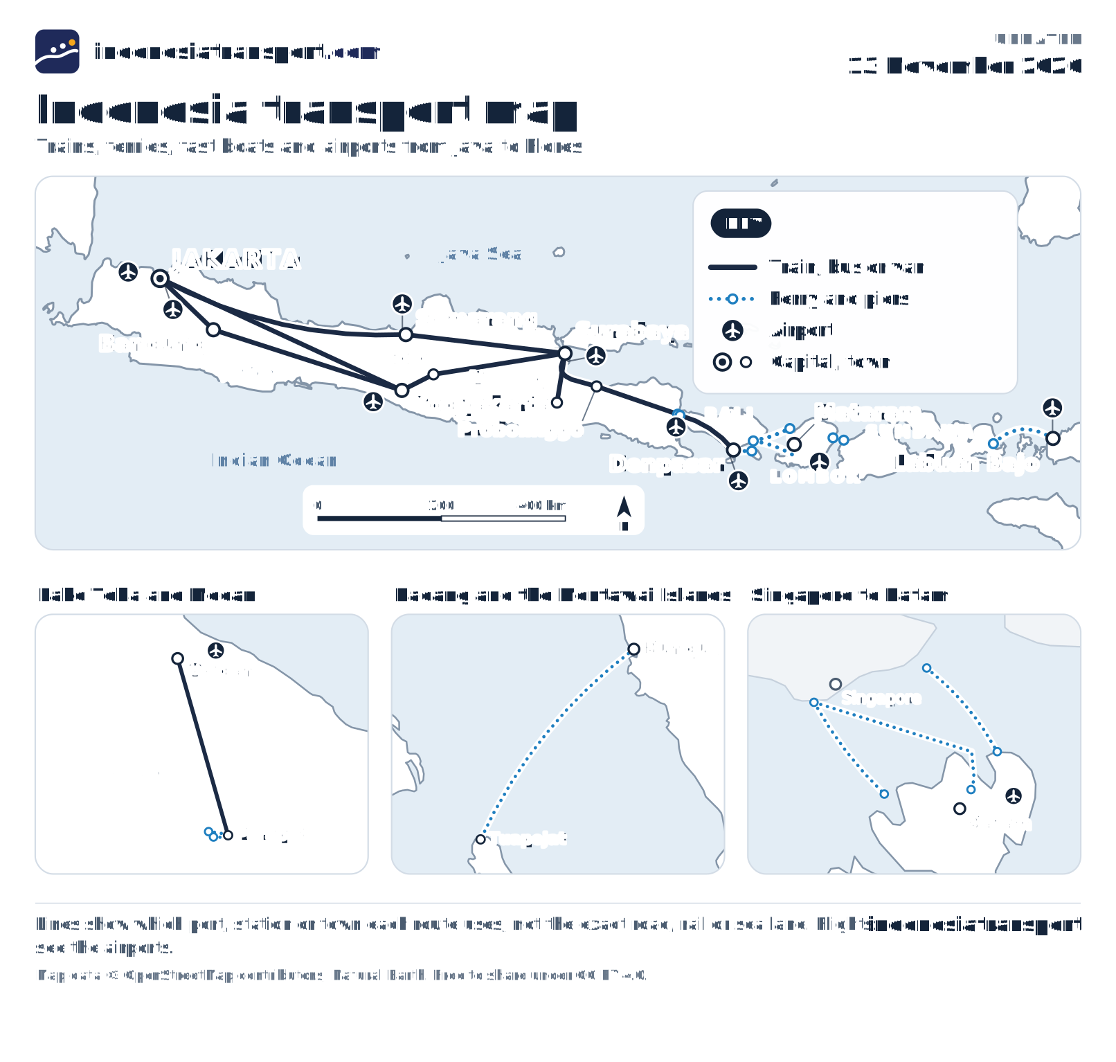
On Java you go by train: the main lines run from Jakarta to Bandung, Semarang, Yogyakarta, Surabaya and on to Ketapang, at Java's east tip. From there car ferries cross to Bali, and from Bali's Padang Bai to Lombok and the Gilis; further east, ferries link Lombok with Sumbawa and Sumbawa with Labuan Bajo. Sumatra's Lake Toba, the Mentawai Islands and Batam each have their own crossing, and long distances are flown.
Reading the map: trains, ferries, fast boats and airports
Solid lines are trains, buses and vans: on Java the main train lines from Jakarta to Bandung, Semarang, Yogyakarta, Solo, Surabaya, Malang and Probolinggo, and on to Ketapang; on Bali the road from Gilimanuk to Denpasar; on Sumatra the road from Medan to Parapat on Lake Toba.
Dotted lines are ferries and fast boats, drawn harbour to harbour. Plane symbols mark the airports the guides send you through; flights themselves are not drawn.
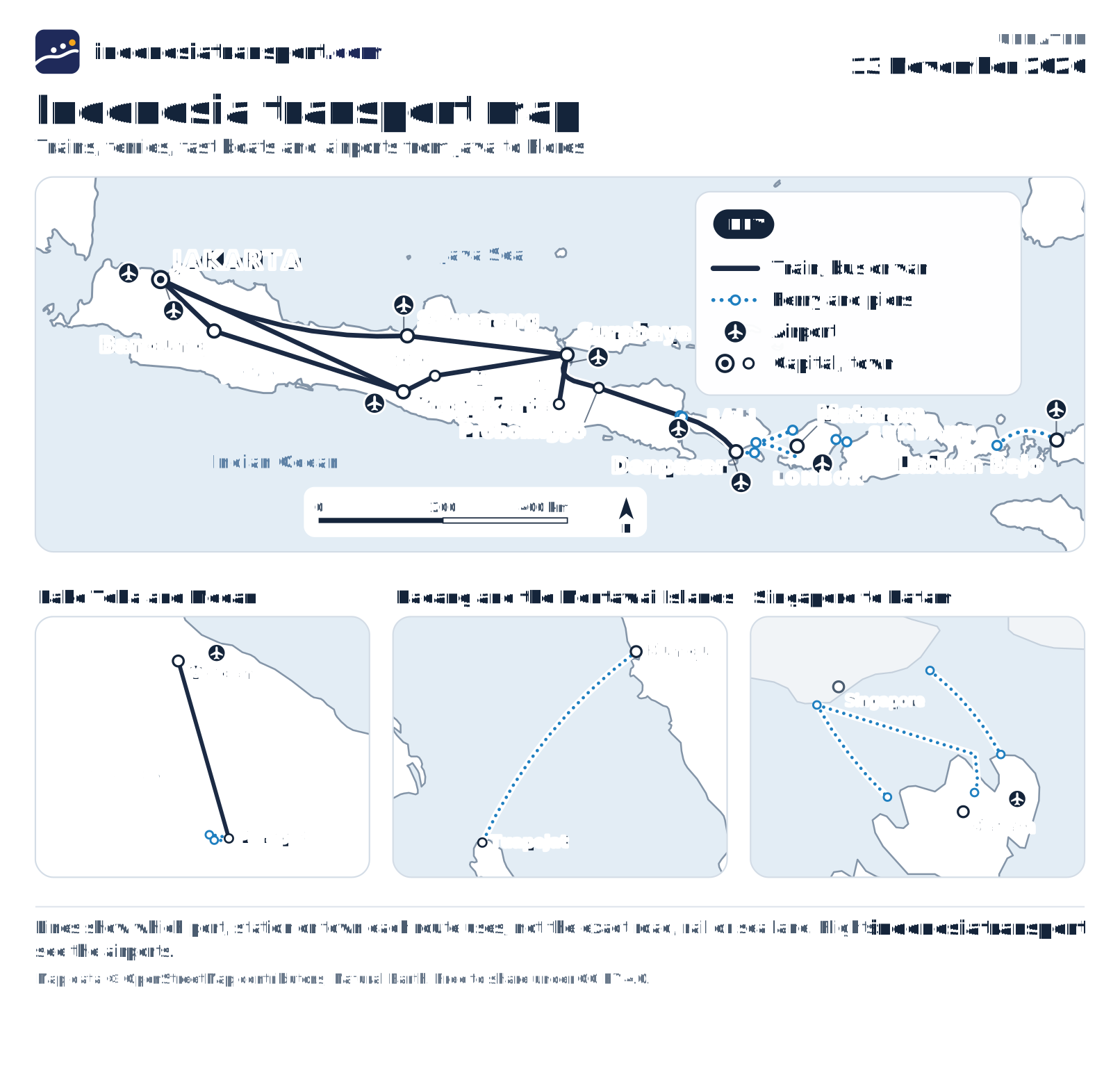
The crossings shown, west to east: Bungus (Padang) to Tuapejat in the Mentawai Islands; Parapat to Ambarita on Samosir; Singapore's HarbourFront and Tanah Merah to Batam Centre and Nongsapura; Ketapang to Gilimanuk; Sanur to Nusa Penida; Padang Bai to Lembar, to Senggigi and to the Gilis; Kayangan to Poto Tano; and Sape to Labuan Bajo.
Java to Flores fills the main map; Lake Toba, the Mentawai ferry and the Singapore to Batam piers each get a close-up card underneath it. Lines show which harbour or station each route uses, not the exact sea lane or track.
Indonesia transport data to download: routes, ports, stations
The routes, harbours, stations and airports behind the map are free to download as JSON, CSV and GeoJSON, one file per card below, under the Open Database Licence (ODbL 1.0), because their positions come from OpenStreetMap. Journalists, app builders and researchers can reuse them with a credit and a link.
Connections
Train, ferry and fast-boat links, with their operators and the page that covers each one.
Places
Towns, ports, stations and airports with their OpenStreetMap positions.
The map
The finished map in this language, upright for phones and wide for screens.
Cite as IndonesiaTransport (indonesiatransport.com), “Indonesia transport routes, ports and stations”, https://indonesiatransport.com/indonesia-transport-map/#data-desk. doi:10.5281/zenodo.24192836
Also on GitHub · Hugging Face · Kaggle · Wikimedia Commons

Same data for the neighbours: Laos · Thailand · Vietnam · Cambodia · Philippines
Share or embed the Indonesia transport map
The map is free to share and embed under CC BY 4.0: copy the code below into your page and it stays up to date as the routes change.
The Indonesia transport map: what travellers ask
Is there a train between Java and Bali?
No. The railway ends at Ketapang, by Banyuwangi in East Java, and a car ferry crosses to Gilimanuk on Bali in 45 to 60 minutes, round the clock.
Which islands can you reach by fast boat from Bali?
Nusa Penida and Lembongan from Sanur, about 30 to 45 minutes; the Gili Islands and Lombok from Padang Bai, about 75 minutes to two hours. Further east, Labuan Bajo and Komodo are flown, 75 to 80 minutes from Denpasar.
Can I use the map on my own site?
Yes, under CC BY 4.0 with a credit to IndonesiaTransport.com; the embed code and the data files are on this page.
Sources for the Indonesia transport map
- KAI (PT Kereta Api Indonesia)
- KCIC: Whoosh tickets and rules
- Radar Banyuwangi: Ketapang-Gilimanuk crossing guide (16 October 2026)
- Satpel Pelabuhan Penyeberangan Lembar (Kemenhub BPTD Kelas II NTB): Padang Bai - Lembar fares
- InsideLombok: Kayangan - Poto Tano tariff (SK Gubernur NTB, 11 January 2023)
- detikBali: Sape - Labuan Bajo ferry fares and holiday schedule (8 December 2025)
- detikSumut: Lake Toba ferry timetable, January 2026 (9 January 2026)
- Metro TV: Padang - Siberut and Tua Pejat routes expected busy at Lebaran 2026 (11 March 2026)